oldravendale
Western Thunderer
Does this help?

Yes, it looks like the train is actually entering a loop, and there’s another track to the right.It appears to me that the train is entering a ”goods loop” and there is another loop terminating closest to the camera. There also appears to be another line to the left of the signal. A study of OS maps is called for.
regards
Mike

according to the oracle that is Google AI, the GW installed their mileposts on the down side, (refers to SRS, whom I believe) and they measured from the Eastern boundary of Padd.
)") .
.That’s interesting, Mike. Had it not referenced the SRS, I’d have been far more suspicious. And, without checking, I’d have guessed Up side.Google AI is wrong, GWR mileposts were/are on the Up side not Down. I agree with Yorkshire Dave, it's approaching Shrewsbury, They call it Coton Hill.

So not only does AI publish unverified data, but it gives a credible source with no obvious link. It’s worse than I feared.

Adam,Yes, that's the intention - it's a feature of Large Language Models, not a bug (as intended, anyway, as used is another matter). All GenAi is hallucination in that it puts words together in ways it 'thinks' fits language use patterns without any recourse to fact. That's why its of next to no use for any form of historical enquiry - such as where the GWR put its mile posts. It's very good at 'inventing' credible looking sources; this is the bane of the teacher and editor's life. 'AI' can provide tools that do exciting things, which do help historical research, but only in specific and limited areas.
Anyway, to return to the photo - behind the raft of vans, there's something obviously 'special' some sort of Weltrol or something - @oldravendale, is there any chance of a blow up?
Adam
")
Adam,
I liked your post, but I don’t like the Info therein. I rather fancied that if it gave a link, the link gave the data that the AI quoted. How foolish of me.
Back to the matter in hand, I agree with your Weltrol diagnosis, on the other hand
cheers
Simon
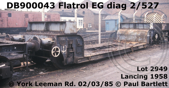
That is a one off, rather more likely to be the LMS design that BR built another 48 of, the MVV BR 4 wh. Flatrol MVV diag 2/512 2/904 ZVO ZVR ZXO ZXP ZXR ZXQ As can be seen they also have the twin hand brake wheels, and could have a supporting beam along the wagon. But could be several other Flatrol or Weltrol.Thanks Brian - a Flatrol with a fairly substantial structure on it and brake wheels at each end. One of these, perhaps?
BR Flatrol EG DB900043 Diag 2/527
The unique Flatrol EG which was RIV equipped for the ferries. Why it was painted grey I cannot explain, perhaps being equipped with through Westinghouse brake pipe but not vacuum brake it was considered to be unfitted?paulbartlett.zenfolio.com
Adam
We used to have that on the Ffestiniog, then we added the Welsh Highland and from Porthmadog it became up both ways… . We now quote Blaenau direction and Caernarfon direction.Up/Down blah Paddington blah. In a Welsh valley it is Up up the hill!