Focalplane
Western Thunderer
I have been doing more research on the area of northwest Houston, using old maps and the history option on Google Earth. Houston grew rapidly after WWII and much of the development outside today's Loop 610 wasn't there prior to c.1955. Neither was Loop 610. It is interesting how these days everything is referenced with respect to the interstate system. But having had my feet on the ground, so to speak, it is relatively easy to work out what has been redeveloped and therefore what might have been there before.
The development of the railroads show a fascinating movement away from the old centre of the city along the arterial roads that were often parallel to the even older railroads. Pre-WWII the railroads were still in open country and much of the development avoided them, so eventually light industry moved out along the roads and used the railroad for transporting materials and goods. It is these sidings that provide the operational interest. The only problem is that I have discovered that the sidings migrated out away from the city centre. So in 1953 there was no development outside the Loop 610 and therefore no sidings. These were located closer to the city and there is evidence of a few siding still in existence.
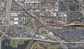
A very good reference point is Eureka Junction. This was built on the outskirts of the city and the junction started out with the predecessors of the T&NO, plus the MKT. I suppose all of it is now under UP ownership with few rights to the other remaining railroad, BNSF.
I hope Google Earth allows screenshots for sharing research, but I will edit these out if not:
First Today's image:
And back to 1953.
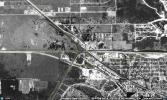
Eureka Junction is in the centre and in the 1953 image the two arterial roads to Hempstead and Katy can be identified. The old MKT (Katy) is no longer there today, having been replaced in the widening of the freeway in 2004.
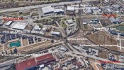
Here is a 3D view of Eureka Junction today, looking more or less south:
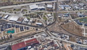
It looks as though Hempstead Road is a working title, but Eureka Heights (the name of the area to the north) might be better. I should explain that an area in Houston slightly higher than its surroundings often has the Heights appendage. Real estate talk for "it doesn't flood here".
Because Houston developed so rapidly, it is difficult to work out exactly what was there at the time of the steam/diesel transition. However, the Google 1953 air photos can be a very good "go by". So that's what can be used, with the layout based on sidings farther to the east, closer to Downtown.
When I went on a UP heritage excursion back in the 1990s, the train (E8s plus heritage rolling stock) started at Eureka Yard (east of Eureka Junction shown on the east of the two now and then maps), backed out of the yard on to the MKT line and then forward toward Eureka Junction, passing slowly through due west to the north side of I-10 (Katy Freeway) on its way to La Grange and Smithville. Most of the MKT is now gone, just the bit between Eureka Junction and Eureka Yard. The section between Eureka Yard and Downtown was considered dangerous with the trains passing very close to housing, so UP closed it down after a derailment. The Katy Freeway portion was "needed" by the freeway expansion though it might have been a good site for a metro line. However, people don't do trains in Houston any more and expansion of the Metro's Line 1 has been stalled for years.
The development of the railroads show a fascinating movement away from the old centre of the city along the arterial roads that were often parallel to the even older railroads. Pre-WWII the railroads were still in open country and much of the development avoided them, so eventually light industry moved out along the roads and used the railroad for transporting materials and goods. It is these sidings that provide the operational interest. The only problem is that I have discovered that the sidings migrated out away from the city centre. So in 1953 there was no development outside the Loop 610 and therefore no sidings. These were located closer to the city and there is evidence of a few siding still in existence.
A very good reference point is Eureka Junction. This was built on the outskirts of the city and the junction started out with the predecessors of the T&NO, plus the MKT. I suppose all of it is now under UP ownership with few rights to the other remaining railroad, BNSF.
I hope Google Earth allows screenshots for sharing research, but I will edit these out if not:
First Today's image:

And back to 1953.

Eureka Junction is in the centre and in the 1953 image the two arterial roads to Hempstead and Katy can be identified. The old MKT (Katy) is no longer there today, having been replaced in the widening of the freeway in 2004.
Here is a 3D view of Eureka Junction today, looking more or less south:

It looks as though Hempstead Road is a working title, but Eureka Heights (the name of the area to the north) might be better. I should explain that an area in Houston slightly higher than its surroundings often has the Heights appendage. Real estate talk for "it doesn't flood here".
Because Houston developed so rapidly, it is difficult to work out exactly what was there at the time of the steam/diesel transition. However, the Google 1953 air photos can be a very good "go by". So that's what can be used, with the layout based on sidings farther to the east, closer to Downtown.
When I went on a UP heritage excursion back in the 1990s, the train (E8s plus heritage rolling stock) started at Eureka Yard (east of Eureka Junction shown on the east of the two now and then maps), backed out of the yard on to the MKT line and then forward toward Eureka Junction, passing slowly through due west to the north side of I-10 (Katy Freeway) on its way to La Grange and Smithville. Most of the MKT is now gone, just the bit between Eureka Junction and Eureka Yard. The section between Eureka Yard and Downtown was considered dangerous with the trains passing very close to housing, so UP closed it down after a derailment. The Katy Freeway portion was "needed" by the freeway expansion though it might have been a good site for a metro line. However, people don't do trains in Houston any more and expansion of the Metro's Line 1 has been stalled for years.

